Uttar Pradesh geography is one of the most scoring parts of UP PCS, because the facts are fixed and the questions repeat in new forms. UP covers 2,40,928 square kilometres, about 7.3% of India’s land, according to the official Uttar Pradesh state portal. Most of it is the flat, fertile Ganga plain, with the Terai belt in the north and the rocky Bundelkhand and Vindhyan plateau in the south.
This post covers the regions, rivers, soils, climate, forests and protected areas of UP, with the exam angle for each.
UP in Numbers
| Item | Fact |
|---|---|
| Area | 2,40,928 sq km, about 7.3% of India |
| Rank by area | Fourth, after Rajasthan, Madhya Pradesh and Maharashtra |
| Population share | Nearly 17% of India’s people, as the state portal notes |
| Districts and divisions | 75 districts in 18 divisions |
| Neighbours | Nepal, and Uttarakhand, Himachal Pradesh, Haryana, Delhi, Rajasthan, Madhya Pradesh, Chhattisgarh, Jharkhand and Bihar |
Note: the state portal’s demography page still says UP is fifth by area, a line from before Andhra Pradesh was split in 2014. With today’s states, UP is fourth.
The Physical Regions
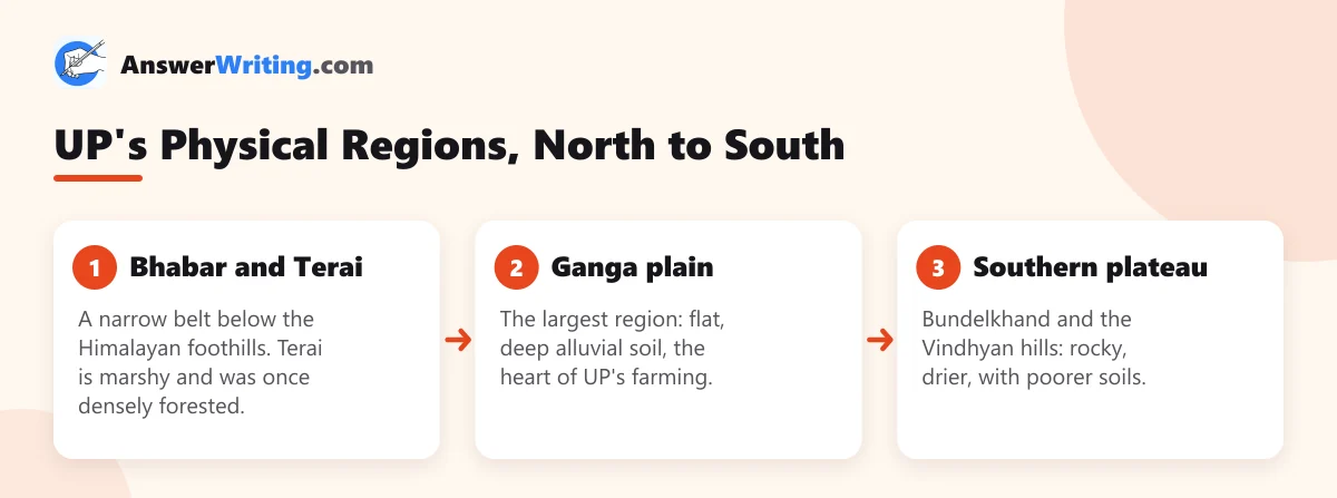
The Ganga plain itself is often divided into the western, central and eastern plains. Rainfall generally increases from west to east, which shapes farming in each part.
Rivers
The state portal lists the Ganga, Yamuna, Gomti, Ramganga, Ghaghra, Betwa and Ken as UP’s main rivers. A simple way to remember them is by where they join:
| Group | Rivers |
|---|---|
| Join the Ganga from the north | Ramganga, Gomti, Ghaghra, Rapti (via the Ghaghra), Gandak |
| Join the Yamuna from the south | Chambal, Betwa, Ken, Sindh |
| The great meeting point | The Ganga and Yamuna meet at Prayagraj (the Triveni Sangam) |
Exam angle: UP PCS likes questions on which river flows through which city, which rivers join the Yamuna, and dams and projects on rivers. Mark each river on a blank map with the main cities on its banks, such as Lucknow on the Gomti and Agra and Mathura on the Yamuna.
Soils
- Alluvial soil covers most of the Ganga plain. The older alluvium is called *bhangar* and the newer, more fertile flood-plain alluvium is called *khadar*.
- Bundelkhand soils are mixed red and black soils. Local names such as *mar*, *kabar*, *parwa* and *rakar* are used for them and are asked in exams.
- Terai soil is fine, moist and fertile, suited to crops like sugarcane and rice.
Climate
UP has a tropical monsoon climate: hot summers, a rainy season from June to September brought by the south-west monsoon, and cool winters. The east gets more rain than the west, and Bundelkhand is the driest and most drought-prone part.
Forests and Protected Areas
UP’s forest cover is low compared with the size of the state, and it is concentrated in the Terai and the southern hills. Prelims 2025 asked which UP districts have forest over more than 20% of their area, a question based on the India State of Forest Report 2023.
The state portal lists these natural places:
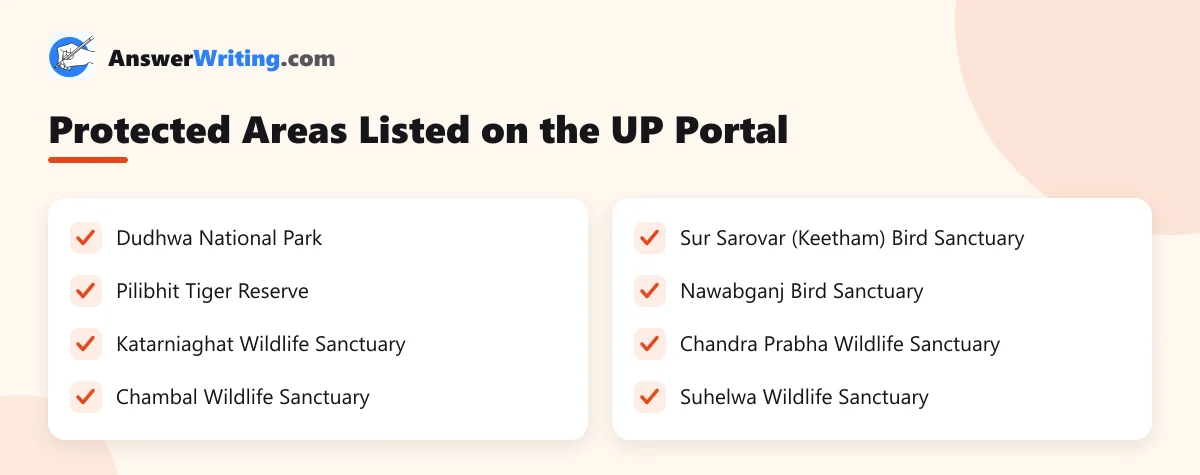
Exam angle: learn each park or sanctuary with its district. Prelims 2025 also asked which national parks or sanctuaries are not in UP, so know the major parks of neighbouring states too.
Minerals and Resources
UP is not a mineral-rich state, but the southern plateau has useful resources. Sonbhadra and Mirzapur in the south-east have limestone and coal-linked industry, and Bundelkhand has building stone such as granite. Questions usually ask which district a mineral or industry is linked to.
How UP PCS Asks Geography
From the official 2025 papers on the UPPSC previous year papers page:
- Prelims asked about forest cover by district, protected areas, the Devipatan division and a district bordering only one other UP district.
- Mains GS VI asked about wildlife-human conflict in UP, soil health in agriculture, biomass energy and mining in Bundelkhand.
So geography links directly to the economy and environment questions of GS VI.
A 5-Step Revision Plan
- Draw the UP outline and mark the three physical regions.
- Add the rivers, then the main cities on each river.
- Mark the protected areas with their districts.
- Write the soil types of each region, with crops.
- Solve the geography questions from the last three UP PCS Prelims papers.
For the district map you need, see our list of UP divisions and districts.
Crops and industries by region are covered in UP economy and ODOP.
Key Takeaways
- UP covers 2,40,928 sq km, about 7.3% of India, and is the fourth-largest state by area.
- It has three physical regions: the Bhabar-Terai, the Ganga plain and the southern plateau.
- Main rivers: Ganga, Yamuna, Gomti, Ramganga, Ghaghra, Betwa and Ken; the Ganga and Yamuna meet at Prayagraj.
- Soils: alluvial bhangar and khadar in the plain, mar, kabar, parwa and rakar in Bundelkhand.
- Learn every protected area with its district.
Practise UP Geography Questions
Map-based questions improve fastest with practice. Use the UP PCS previous year questions and mock tests on AnswerWriting to test yourself on rivers, parks and districts before the exam.
Related Reading
FAQs
What is the area of Uttar Pradesh?
2,40,928 square kilometres, about 7.3% of India’s land area, as per the official state portal.
What are the physical regions of Uttar Pradesh?
The Bhabar and Terai belt in the north, the Ganga plain in the middle, and the southern plateau of Bundelkhand and the Vindhyan hills.
Where do the Ganga and Yamuna meet?
At Prayagraj, at the Triveni Sangam.
What are the soils of Bundelkhand called?
Local names include mar, kabar, parwa and rakar.
Which national park is in Uttar Pradesh?
Dudhwa National Park is the best-known one. The state portal also lists Pilibhit Tiger Reserve and several wildlife and bird sanctuaries.